
-Travel to Provo- -Accomodations- -Tourism-
-Before you Leave- -Upon Arrival- -Map-Orientation and Navigation
Provo is located in a valley between mountain ranges. A lake (Provo Lake) is west and the nearest mountain range (including Y Mountain, identified by the large letter "Y" painted on it) is east.
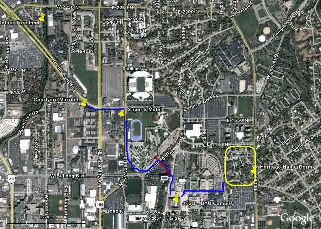
A satellite image of Provo that identifies the areas of interest for the TC37 conference and other associated meetings is provided here. This image shows:
- The location of the three hotels and dormitory where we have booked rooms.
- The location of the building where the conference meetings will take place (TC37 2007 office is located on the fourth floor in room 4051 of the JFSB)
- Pedestrian pathways (in blue). For the most part these pathways denote sidewalks alongside main roads. However, a footpath (highlighted in red) to campus can be accessed by cutting through the dorm on N Canyon Road and passing through a tunnel under E Bulldog Blvd (the second tunnel - immediately west of a construction zone). This path takes you up an incline (BYU sits on a hill-top) so if that will be a problem you may prefer to take a shuttle van that leaves from the Courtyard Marriott and will drop you off within 100 meters of the JFSB.Provo is laid out, mostly, in a grid pattern like a geometric (Cartesian) plane. The (0, 0) coordinates lay at the intersection of University Avenue and Center St (not shown on the map). Every address designates it's distance and direction from this center point. Ten blocks is roughly equivalent to 1 mile; or an address number of 1000 is one mile from the center point. For example, the Courtyard Marriott, at 1600 N Freedom Boulevard is 1.6 miles north of Center St. By implication, 6 blocks is a little less than 1 kilometer. Therefore, looking at the map provided, the Marriott is about 4 blocks from the Super 8 Motel, or less than half a mile or 2/3 of a kilometer. Hopefully, this will help to gauge distances when selecting restaurants or other excursions by allowing you to compare their address with your hotel address.
Finding your way on Campus
There is a campus map available at http://map.byu.edu/ with a link that will let you download it to a PDF. The JFSB (Joseph F. Smith Building) is #70 on that map. The dorms (Heritage Halls) where we have two buildings reserved are #45. Other places of interest are the Student Center (WSC- Wilkinson Student Center, A.K.A the Wilk) #93, the Harold B. Lee Library (HBLL) #54, and the Museum of Art (MOA) #63. If you stop someone on campus to ask directions and they are unfamiliar with the JFSB (it's a fairly new building) you might, instead, ask for:
- the new humanities building.
- the library (the JFSB is just west of the library).
- the TMCB or math building (the JFSB is just to the south).
or go to the tallest building on campus (Kimball Tower) and look north. You should see the JFSB (a large 5 story building with an inner court, that is mostly glass on the east side, and has a playground on the west side).If you need help, contact us in one of the following ways:
Phone numbers for help:
1. TC37 Conference office (located at 4051 JFSB) - +1(801)422-2144 -- if calling from another phone on BYU campus, just dial 22144.
2. Dr. Alan Melby +1 (801) 360-0703 -- from a landline in Provo, you only need dial the last seven digits (360-0703) unless you are on campus, in which case you first dial 9 to get an outside line, or in a hotel, in which case you ask the front desk how to get an outside line.
2. Nathan Simmons -
3. Dr. Sue Ellen Wright +1 (330) 389-06604. BYU Dept. of Linguistics and English Language +1(801)22-2937 -- if calling from another phone on BYU campus, just dial 22937.